
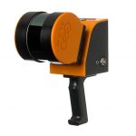

GeoMax Zoom3D Series 3D Scanner
Original price was: $4100.$2050Current price is: $2050.
GET STARTED WITH THE PRESS OF TWO BUTTONS
1. Place your Zoom3D on the floor or on the tripod
2. Turn it on. The Zoom3D automatically levels
3. Connect it to your datalogger and start working!
Description
GeoMax Zoom3D Series 3D Scanner
Upgrade to an innovative and user-friendly robotic total station. Simply position it and turn it on. The Zoom3D will measure and layout any project site. With simple configuration and equipped with an auto levelling feature, the Zoom3D is a plugand-play solution that speeds up your daily tasks. The Zoom3D is the ideal partner for all daily tasks in any small construction site, from as-built survey to the stakeout. Its user-fiendly onboard software helps with a wide range of indoor applications, such as measuring, setting out or plumbing points. For your outdoor tasks, the micro robotic solution is equipped with target recognition technology that automatically and easily centres and follows the target, allowing surveys and stakeouts in small construction sites.
TWO EASY AND APPLICATION-RICH OPTIONS
With very simple configuration and equipped with an auto levelling feature, the Zoom3D is a plugand-play solution that speeds up your daily tasks. Its user-fiendly onboard software helps with a wide range of indoor applications such as measuring, setting out or plumbing points. Levelling can now be completed with greater ease and speed, then exported in most common file formats. For your outdoo tasks, the Micro Robot solution is equipped with target recognition technology that automatically and easily centres and follows the target, allowing surveys and stakeouts in small construction sites.
UPGRADE IT TO MICRO ROBOTIC SOLUTION
Save time and resources by upgrading your Zoom3D to a Micro Robotic Solution for all your one-man operations. Its powerful software is equipped with a target recognition technology, automatically aiming and tracking the target mounted on a standard TPS pole. The Zoom3D is the ideal partner for all daily tasks in any small construction site for all daily tasks, from as-built survey to the stake out.
GET STARTED WITH THE PRESS OF TWO BUTTONS
1. Place your Zoom3D on the floor or on the tripod
2. Turn it on. The Zoom3D automatically levels
3. Connect it to your datalogger and start working!
GeoMax Zoom3D Series 3D Scanner
PLUG AND PLAY SOLUTION
• Simple configuration
• Auto levelling feature
MICRO ROBOTIC SYSTEM
• Target recognition technology
• Auto targeting and tracking functions
• Ideal for small construction sites
YOUR INDOOR PARTNER
• Highly accurate 3D measurements
• User friendly onboard software
• Full set of applications and easy data export
MILIMETRE ACCURACY
Error-free results in every working condition.
SELF-LEVELLING
No matter where you place your Zoom3D, its self-levelling feature will level automatically and start to measure.
WI-FI
Wi-Fi connection in all Windows devices up to 50 m.
TARGET RECOGNITION
With the Zoom3D target recognition technology you can measure and stake out using a pole for all your one-man operations.
3D MEASURING
Press just one button to take 3D measurements. The Zoom3D software will allow you to visualise and rotate your 3D survey.
CAMERA
Easily aim and precisely zoom in on a point with the tablet and its 5MP camera.
GONIOMETER
Measurement range: Horizontal 360°; vertical 250°
Accuracy: 5˝, equates to 1.2 mm @ 50 m
LASER DISTANCE METER
Type: Coaxial, visible red laser
Measurement: range 0.5 – 50 m
Laser class: 2
Laser type: 650nm; < 1mW
ø laser dot (at distance): 10 m: ~7 mm ×7 mm 30 m: ~9 mm ×15mm
TIE DISTANCE ACCURACY (3D)
Angle and distance: @10 m @30 m @50 m
combination: Approx. 1 mm 2 mm 4 mm
TILT SENSOR
Self-levelling range: ±3°
Accuracy: 10˝, equates to 2.5 mm @ 50 m
DIGITAL POINT FINDER
Zoom (magnification) /
Field of view (@ 10 m)
1× / 3.40 m × 2.14 m
2× / 1.70 m × 1.07 m
4× / 0.85 m × 0.54 m
8× / 0.42 m × 0.27 m
CIRUCLAR LEVEL SETTING
Accuracy: 1°/mm
OPERATION
Keys/user interface: 1 on /off button
Interfaces: USB type B, power supply power pack
COMMUNICATION
Cable: USB: Micro-B USB and type a; WLAN
Wireless: 50m range **
POWER SUPPLY
Internal battery: Li-Ion battery 14.4 V / 63 Wh
External power: 24 VDC / 2.5A, charging time 8 h
Operating time: 8 h
PHYSICAL SPECIFICATIONS
Dimensions: Height 215.5 mm, ø 186.6 mm
Weight: 2.8 kg
Operating temp.: – 10°C to 50°C
Storage temp.: – 25°C to 70°C
Protection class: IP54 (IEC 60529)
Attachment: 5 ⁄ 8” thread
REMOTE CONTROL
Range: 50 m **
Communication: Infrared (IR)
Battery: 1 AA, 1.5 V
* Accuracy is specified at 20°C; ** Depending on environment.
1115 – 840795 en
Copyright GeoMax AG.
Illustrations, descriptions and technical
specifications are not binding and may change.
All trademarks and trade names are those of
their respective owners.
Related products
-
- Sale!
- 3D Laser Scanner
Leica RTC360 3D Laser Scanner
- Original price was: $32000.$15999Current price is: $15999.
- Add to cart
-
- Sale!
- 3D Laser Scanner
GeoSLAM ZEB REVO RT Handheld 3D Scanner
- Original price was: $24000.$14200Current price is: $14200.
- Add to cart
-
- Sale!
- 3D Laser Scanner
FARO Focus S 150 Laser Scanner
- Original price was: $20000.$9950Current price is: $9950.
- Add to cart


Reviews
There are no reviews yet.